Explore our map to discover more about where rewilding is happening across Yorkshire. Find out what’s happening near you and how to get in touch with fellow rewilders.
Rewilding and not on the map? Enter the details of your site here.
To be included on the YRN map your project should be following rewilding principles and letting nature take the lead. Rewilding can happen at any scale and we welcome garden projects too. You can check if you are indeed rewilding your garden by following this link to Rewilding Britain’s “How to make your garden wilder“.
Please note, site locations are displayed based on the site postcode and are therefore not precise.
How to use the map
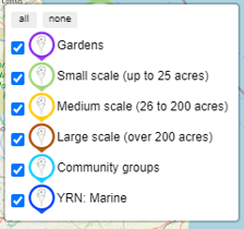
The markers on the map show the approximate locations of projects across the Yorkshire Rewilding Network, colour-coded according to the type of project.
You can click the markers and the buttons that you can see on the map, as follows.
Project markers
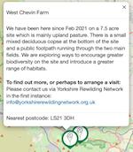
Click on a marker and an information box will pop up telling you about that project and how to contact the project or site manager.
For example:
On the left of the map, you will see 3 buttons. They are:

Zoom in and out
This allows you to zoom in and back out each time you press one or the other.

View fullscreen
Pressing this will maximise the map to your device’s entire screen. Once in the full screen view, the button changes to this:

Pressing this will return the map to its original size.

Reset map view
This will return the map to the original view extents.
On the right of the map, you will see 2 buttons. They are:

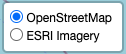
Set basemap
This button allows you to switch between different base maps.

Legend
Pressing this will show you what category of rewilding project the map icons represent. You can toggle different ones on and off.